- اردو میں معلومات
- niopk.gov.pk@gmail.com
- +92 21 99251172-78
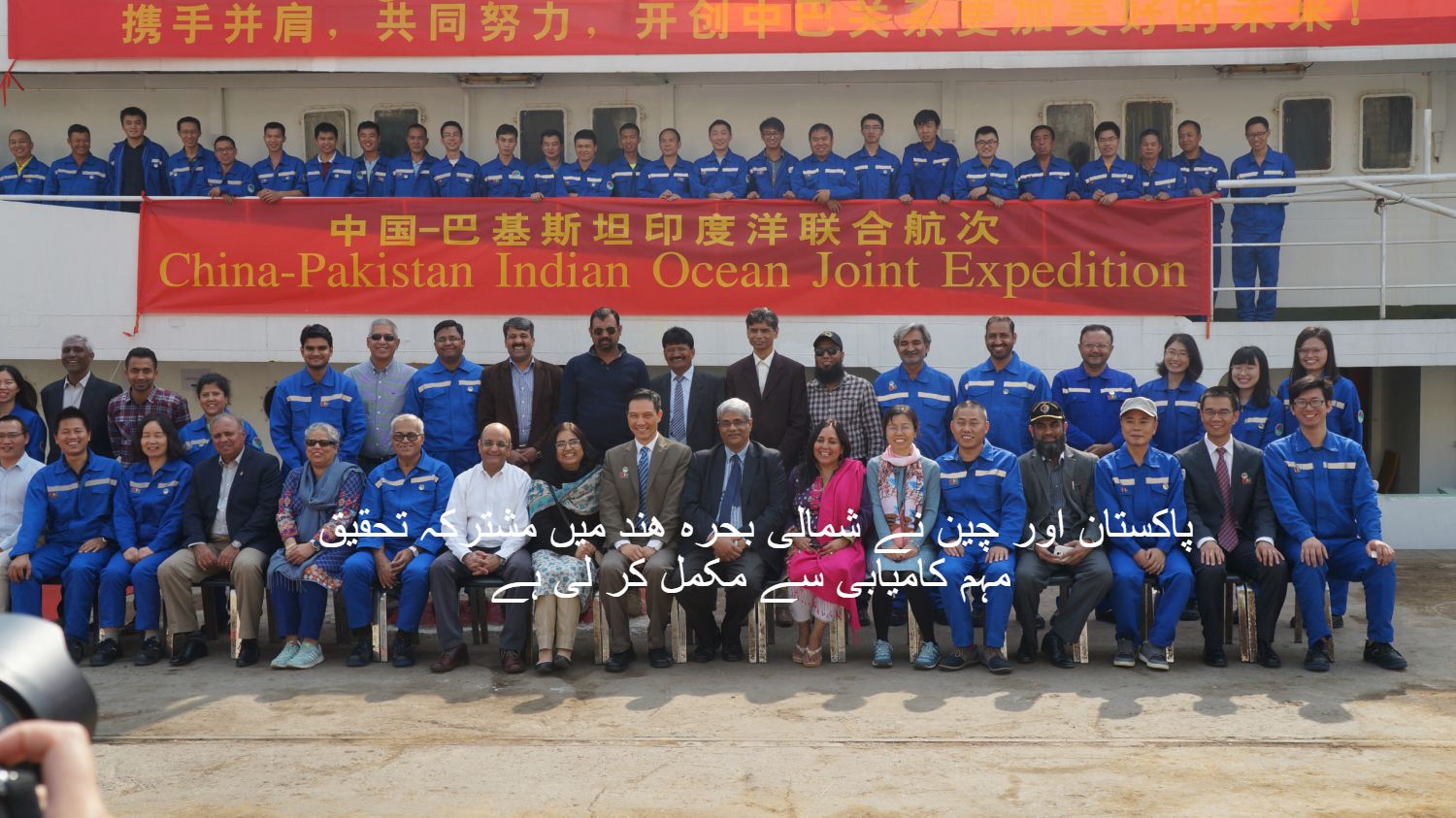
چوالیس ممبران پر مشتمل ایک مضبوط ٹیم جو کہ پاکستام اور چین کے سائنس دانوں پر مشتمل تھی ۔ انہوں نے مکران کی بھریاتی تحقیقی مہم کامیابی سے مکمل کر لی ہے اور ٹیم تین ہفتے سمندر میں مصروف کار رھنے کے بعد واپس کرچی پہنچ چکی ہے۔ اسی مہم کے دوران ارضیات ، طبیعات اور بحریاتی سروے مکمل کیے گئے اور تحقیق کے لیئے مختلف قسم کے نمونے حاصل کیئے گئے ۔ اس میں پاکستانی ٹیم کے ۸ ممبران تھے ۔ جن میں سے ۷ کا تعلق قومی ادارہ بحریات سے تھا ، جبکہ ایک ممبر کا تعلق پاکستان بحریہ سے تھا۔
چین کے وفد کی قیادت پروفیسر جیان لن نے کی ۔جو کہ ساؤتھ چائنہ سی اینٹی ٹیوٹ آف کے ڈپٹی ڈائیریکٹر جنرل ہیں۔ چین کی ٹیم ۳۵ سائنس دانوں پر مشتمل تھی۔ جو کہ چین کے تحقیقی جہاز ( شیان ۳) کے ذریعے کراچی تشریف لائے تھے۔

“قومی ادارہ بحریات کے سائنس دان اس سے قبل چین کی بر اعظم انٹارکٹیکا کی مہم کے علاوہ چین کی جنوبی بحر ھند کی مہم میں بھی شرکت کر چکے ہیں ۔ یہ پہلا موقع تھا کہ دونوں ممالک نے بحریہ عرب میں مشترکہ طور پر ارضیات ارضی طبیعیات اروبحریات سروے مکمل کیئے ۔ قومی ادارہ بحریات کے ڈائیریکٹر جنرل ڈاکٹر اصف انعام نے بتایا کہ اس مہم کا تحقیقی علاقہ مکران کے ساحلی پر واقع شہر پسنے کے سامنے کا علاقھ تھا ۔ یہ بات روزنامہ ڈان سے گفتگو کرتے ہوئے کہا۔
"اس تحقیق مہم میں جن ماہرین نے حصہ لیا ۔ ان میں ڈاکٹر من چو، ڈاکٹر فین زانگ، ڈاکٹر ھانگ فینگ پانگ، ڈاکٹر گانگ لی۔ جبکہ پاکستان کی جانب سے سید عمران حسینی ، وسیم حیدر، صنوبر کہکشاں ، ڈاکٹر نور احمد کلہوڑو، خالد محمود ، عزیز لودھی ، انور زیب اور اسد اللہ میمن نے شرکت کی۔"
...مذید جانیے
فروری 4, 2018,ڈان میں تاریخ اشاعت
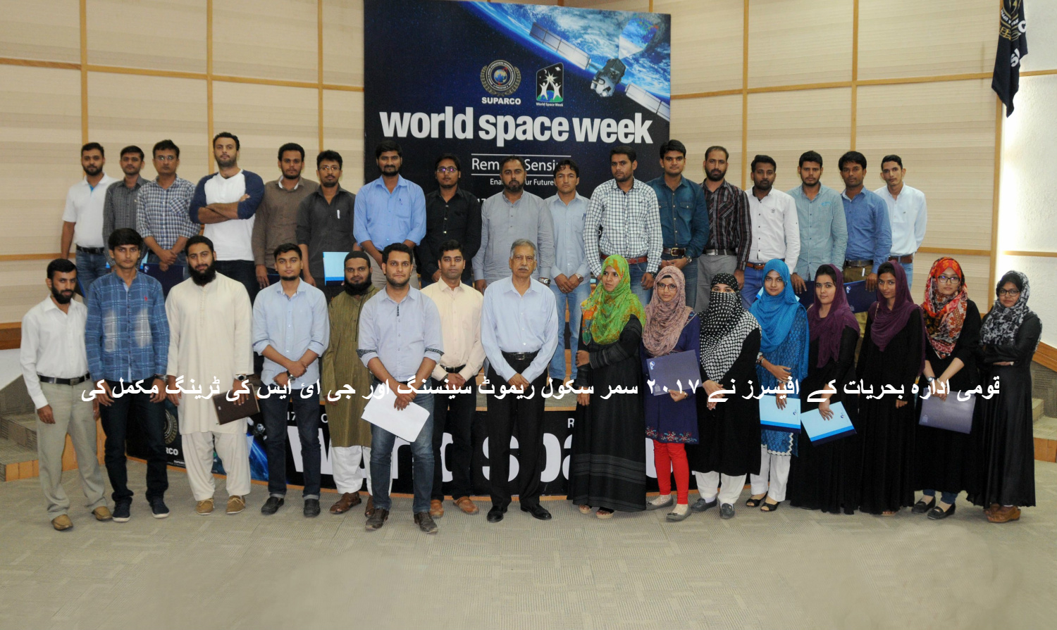
2017 Summer School on Remote Sensing & GIS

NIO officer successfully completed "2017 Summer School on Remote Sensing & GIS", organized by National Center for Remote Sensing & Geo-Informatics, Institute of Space Technology, Karachi,on August 1-10, 2017, at National Center for Remote Sensing and Geo-Informatics, SUPARCO HQs., Karachi
During the training participants had hands-on training on remote sensing softwares and its application.
Astola island declared country’s first marine protected area

Astola island, a major biodiversity hotspot and the largest island along Pakistan’s coast, was declared the country’s first marine protected area through a notification issued by the Balochistan government on Thursday.
The island covers an area of about 400 square kilometres and is located 39km east of Pasni, Balochistan. It is صفحہ اول to several species of marine and terrestrial animals and plants. The deadly Russell’s viper (Echis carinatus astolae), a highly venomous snake, is endemic to the island. It also a nesting place for many sea birds, especially the greater crested tern (Thalasseus bergii), which have thousands of nests on the island.Astola Island’s sandy beaches are a nesting ground for green turtles and around 25 species of coral have been found in the ocean around it.
“By declaring the Astola island a marine protected area, Pakistan has started its compliance with the Aichi Target 11, which requires that by 2020, at least 17 per cent of terrestrial and inland water areas and 10 per cent of coastal and marine areas are to be conserved,” Muhammad Moazzam Khan, technical adviser on marine fisheries with the WWF-P, said. The step taken by the Balochistan government would ensure that the island’s biodiversity would be protected, the use of deleterious fishing methods will be stopped and recreational activities would be controlled, he added.

“It will also ensure that protected, threatened and endangered species of crustaceans, coral, mammals, sharks, turtles, whales and mobulids will be conserved. Moreover, whale sharks, sunfish, guitarfish and seabirds will not be harvested or killed,” he said.
“Subsequently, a motion submitted from Pakistan was adopted at the IUCN World Conservation Congress 2016 calling for the declaration of Astola Island as a marine protected area in Pakistan,” he recalled.


Citing international conventions on nature conservation, he pointed out that Sustainable Development Goals (SDGs) agreed by the UN General Assembly in September 2015 had called for conservation and sustainable use of the oceans, seas and marine resources for sustainable development (SDG 14).
“Change in land and sea use shall not be allowed in the protected area except with prior permission of the government, where the change is likely to enhance the conservation value of the protected area in terms of biodiversity and other elements of nature subject to and within the permitted scope of Convention on Biological Diversity,” the notification says.
Published in Dawn, June 16th, 2017
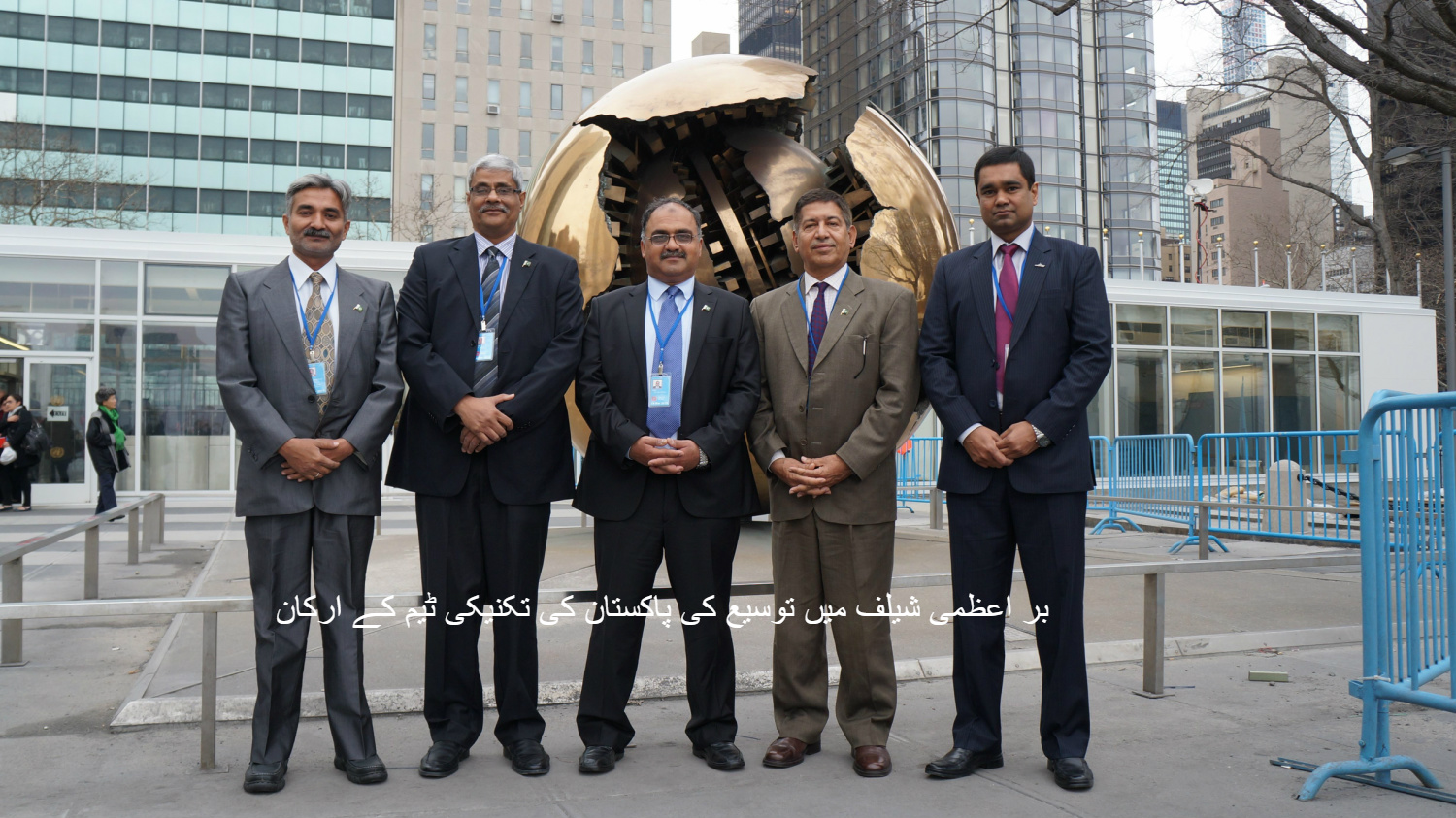
پاکستان کے بر اعظمی شیلف میں توسیع
ااقوام متحدہ کے کمیشن برائے بر اعظمی شیلف نے بروز جمعہ ۲۱ مارچ ۲۰۱۵ کو یہ اعلان کیا کہ پاکستان کے بر اعظمی شیلف کی توسیع کی سفارشات کو تسلیم کر لیا گیا ہے۔ اس کے اعلان کے اور پاکستان کا بر اعظمی شیلف جو کہ ۲۰۰ ناٹیکل میل تھا ۔ وہ بڑھ کے ۳۵۰ ناٹیکل میل ہو گیا ہے ۔ جس سے پاکستان کو مزید ۵۰،۰۰۰مربع کلو میٹر علاقہ اضافی مل گیا ہے ۔ جس سے پاکستان کا معاشی مفاد کا علاقہ جو کہ پہلے ۲،۴۰،۰۰۰ مربع کلو میٹر تھا۔ ان یہ بڑھ کر ۲،۹۰،۰۰۰ مربع کلو میٹر ہو گیا ہے۔
سمندر کوجانیے
اپ جھاں کھیں بھی رھیں،سمندر آپ کی ذندگی کو متاثر کرے گا
پروٹین مچھلیوں سے حاصل کیا جاتا ہے۔
ہمارا سمندر منجمد برف سے ڈھکا ھوا ہے
سمندر کی مکمل جانچ پڑتال نہیں
کی انسانوں نے اب تک
کاربن ڈائی آکسائیڈ جو کہ کرہ ہ
وائی میں موجود ہے ۔ اس کوسمندر اپنے اندر
جزب کرتے ہیں۔
بین الاقوامی ترسیلات سمندر
کے ذریعے ھوتی ھے
قومی ادارہ بحریات کی خدمات کا دائرہ کار
ساحلی علاقوں میں سمندروں کی حرکا ت اور سمندر کی تہوں کا سروے کرنا۔
سمندری آلودگی کا شاہدہ اور مطالعہ کرنا۔
بحریاتی سروے کرنا۔
ماحولیاتی سروے کرنا۔
سمندروں کے بارے میں معلومات جمع کرنااور ارضیاتی انجیئرنگ سروے کرنا
بحریا تی اعداور شمار کی فراہمی کی خدمات فراہم کرنا۔
مکمل تفصیلی منصوبہ بندی کرنا۔ مشاہدہ اور مطالعہ کرنا۔
جھینگوں کی افزائش گاہ اور پیداوار۔

- سسٹریٹ ۴۷،کلفٹن بلاک نمبر ۱، کراچی ۷۵۶۰۰، پاکستان
- +92 21 99251172-78
- +92 21 99251179
- +92 21 34166418
- niopk.gov.pk@gmail.com

قومی ادارہِ بحریات پراجیکٹ گیلری


